After exiting the Horseshoe Canyon section of Canyonlands NP, we continued riding east on the old oil company road. The LaSal Mountains, near Moab, were directly ahead, looking misty. Our destination was The Spur, a mesa top with a number of lookout points that resemble the rowels of a spur from an aerial view.
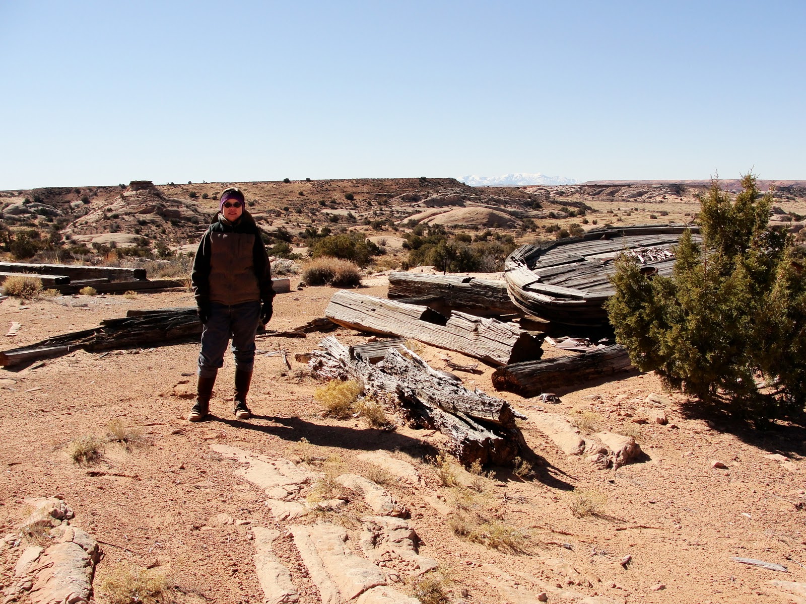
We found this old oil well site on our route, apparently the one for which the road across Horseshoe Canyon was built. Steve is standing on the "bull wheel" with Sugarloaf Butte in the background. Best I can tell, this wheel acted as part of the mechanism of pulleys and cables that rotated the drill pipe as the bit forced its way into the earth. The men would pull out the pipe periodically and sharpen the drill bit by hand, apparently by hammering on it until it formed a point again. The process was pretty primitive.
The clean up was primitive as well. The old drill rig (some of the beams are behind me on the left in the photo above) was never removed, and the skeleton remains in the sand, along with the old wheel, some huge cable spools, etc. This seems a little reminiscent of the Shelley poem, "Ozymandias."
"Two vast and trunkless legs of stone
Stand in the desert. Near them on the sand,
Half sunk, a shattered visage lies...
...Round the decay
Of that colossal wreck, boundless and bare,
The lone and level sands stretch far away."

Not all of the leavings were wasted, though. Just up the trail a little way, some enterprising ranchers built a corral out of salvaged cable. Waste not, want not. One man's trash is truly another man's treasure.
The view from the Spur was impressive. The line of rock outcroppings in the photo outline Horseshoe Canyon, from which we came. We continued along old two-tracks and cow trails, trying to find some springs Steve had seen on his topo map and marked on his GPS. No luck there. Either the springs are misplaced on the map, or they have dried up since the mapping was done.

No matter. We rode sandy trails on a nice day, and the views alone were worth the trip. The above photo shows the distant LaSal Mountains. In the foreground are Navajo sandstone domes, and slightly lower are the Wingate sandstone cliffs along the Green River Gorge. The photo is taken from the vantage point of The Spur, about 600 feet higher than the surrounding desert of the Canyonlands Maze District. Geologists say that the Navajo sandstone was formed by an eolian (windblown) process about 180 million years ago. Uplift and subsequent erosion about 15 million years ago exposed these formations, and since that time, further erosion formed the deep canyons. The Navajo sandstone domes resemble, and essentially are, fossilized sand dunes with their characteristic crossbedding.
If you would like to read about the history of this area, I recommend a couple of fascinating interviews with Ned Chaffin, a man whose family ranched there in the '20's and '30's. Links to the interviews are posted on the the Canyonlands National Park site, and I include them here:
http://www.nps.gov/cany/historyculture/loader.cfm?csModule=security/getfile&PageID=529627
http://www.nps.gov/cany/historyculture/loader.cfm?csModule=security/getfile&PageID=503334


 No matter. We rode sandy trails on a nice day, and the views alone were worth the trip. The above photo shows the distant LaSal Mountains. In the foreground are Navajo sandstone domes, and slightly lower are the Wingate sandstone cliffs along the Green River Gorge. The photo is taken from the vantage point of The Spur, about 600 feet higher than the surrounding desert of the Canyonlands Maze District. Geologists say that the Navajo sandstone was formed by an eolian (windblown) process about 180 million years ago. Uplift and subsequent erosion about 15 million years ago exposed these formations, and since that time, further erosion formed the deep canyons. The Navajo sandstone domes resemble, and essentially are, fossilized sand dunes with their characteristic crossbedding.
That is very interesting. The oil drilling stuff is old. When I started in the industry way back the old guys would talk about using cable tools back in the 40's and earlier.
ReplyDeleteGreat scenic views.
I have mixed feelings about the mining artifacts, fun to find but should it have been left behind.
ReplyDeleteI really like the idea of riding in the canyon and then looking back at it.
This is a great ride.
Maybe we can meet somewhere for a shamans gallery hike.
I have come across many old mining sites in my travels about the deserts. "Primative" is a good way to describe their methods. I am amazed at the amount of effort needed to bring in all the gear and supplies to such remote locations, not to say anything about the mining process itself. The rewards (if any) truly had to make it very worthwhile. I would never had what it took to be a miner. Great post.
ReplyDeletewhat a fabulous place --and great pictures, Janie... That old oil well (the remains) is interesting... Gee---that has been there for awhile, hasn't it????
ReplyDeleteThe views from the Spur were amazing... Just miles and miles and miles of pure beauty... Wow!!!!
Thanks..
Hugs,
Betsy
Stunning views! The sky, the rock, the gresses...even the snow on the mountains.
ReplyDeleteJanie..your photos are beautiful...I love hearing about your adventures...
ReplyDeleteThank you so much for stopping by Team Beaglebratz - it really helps to remind me to get over here to see what your latest travels have been. I have finally learned how I can really zoom in with my computer so I can really check out all your beautiful pictures - they are great!
ReplyDeleteMom Beaglebratz (Kim)
Thanks for taking us along with you on another wonderful ride. Your pictures are absolutely spectacular.
ReplyDeleteWhat a landscape!!!
ReplyDeleteParappalaru Falls - A picture Album
The views are gorgeous...I never tire of seeing what YOU see!!!
ReplyDeleteI learned some things about my own back yard today. Fun ride.
ReplyDeleteYour trip photos make my mouth water! I was born and grew up in south central Utah/ Northern AZ, and Cortez colorad. my Dad and I traversed these locations many times in his old ford pickup truck. He passed away in 2001 and I have lived in Virginia since 1991. I miss that part of this country and have fully enjoyed seeing it again through your photos.
ReplyDelete