 We've ridden to Grayhead Peak (9500 feet - shown above) before, but we've never ridden the ridges over to Grayhead benchmark, about 50 feet higher and 2.5 miles to the northeast as the crow flies.
  This time, we follow faint game trails over hill and dale, literally, to reach the benchmark. Mischief and I head uphill in the photo above. If you enlarge, you should be able to see the arrows I've used to show our "trail."
Below is a view of the trail from Google Earth:
 We keep going up:
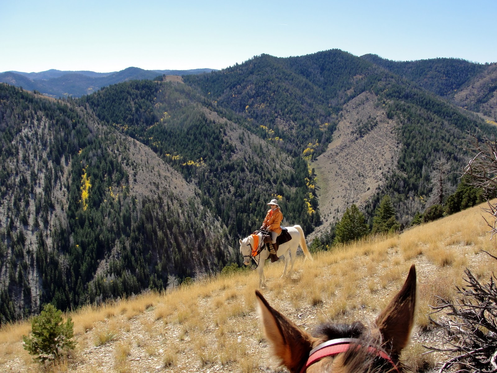 And up:
 Until we finally reach the top, catching up with Steve, Boss, and Daisy:
 Daisy is traveling with us again, now that she's made a complete recovery from being stepped on a couple of weeks ago.
  Since there were no creeks or springs on this ride, I rigged a drinking bowl and gave her some of my water. The horses can wait longer between drinks. Even though they went a total of 14 miles and 3800 feet elevation gain and loss, they did fine without water.
  Boards and nails indicate a fallen structure next to the benchmark:
 We guess that it is the remains of a platform or tripod for a heliograph, a communication device featuring a mirror for simple Morse Code type messages. A heliograph may have been used by USGS surveyors long ago when the benchmark was placed, or perhaps by the Forest Service for communication between rangers.
  On our way down, we stop on one of the remote ridges. There is no trail whatsoever, but we happen to spy this forest service sign almost obscured by a tree branch:
 Up close, it indicates the way to a canyon, but who would ever see this sign?
  Not many people travel off trail, as we do. I doubt anyone else has seen the sign, or found their way to Wilbur Canyon, in quite a few years. Hmm, maybe we should go there on our next ride...
You guys are hard core. What a ride.
ReplyDeleteHi Janie, congrats!!!! The Benchmark is AMAZING.... You are truly on the top of the world!!!! Wow--that is truly awesome.
ReplyDeleteInteresting sign --which nobody sees. ha ha
Have a great week.
Hugs,
Betsy
What a magnificent view from Grayhead Peak. Sure glad Daisy is healed and back on the trail. I didn't notice a date on that bench mark. I'm sure Steve will be scopeing out this new trail on his maps.
ReplyDeleteThe panorama from Grayhead is absolutely stunning. Thanks for taking us along on this ride. When do you think we'll get to Wilbur Canyon?
ReplyDeleteWhat an amazing feat making it up that high and far.
ReplyDeleteLOVE the panoramic view.
Glad Daisy is feeling better. :)
Wow, impressive. I like your picture that shows your route, that's cool. And funny about the sign to Wilbur Canyon. It does sound like a good destination for next time.
ReplyDeletewow--that was quite a ride. thanks for sharing. I love seeing these glimpses of your part of the state.
ReplyDeleteWell done! What a marathon! Your animals must be very fit (and you).
ReplyDeleteThank you for these amazing photographs.
Wow! What a spectacular journey. I could not imagine such a long trip at that altitude.
ReplyDeleteJanie: What a neat post showing the wonderful country in which you travel. You show your travels in such a neat way.
ReplyDeleteThat's amazing country. Love the photo with the arrows. Can't believe you were able to ride it without sliding down one side. (Whew!) Such an interesting shape to those ridges. It's hard to believe you can ride a horse along them. Rugged yet weirdly accessible, and rarely traveled. Those signs and benchmark are mind blowing. To think who put them there. Wow!
ReplyDeleteThe places where you ride always amazes me!
ReplyDeleteWow, what a ride that was. You two are extremely adventurous to go wandering that far from civilization.
ReplyDeleteBe well, be Happy and safe, Janie.
Say Hi to Steve and pet the crew for me... :)
This post was fascinating! I enlarged every photo. Wonderful panorama from the benchmark. Whew, what a ride, On to Wilbur Canyon?
ReplyDeleteI've been thinking about your ride but every time I think about it, it scares the crap out of me! Maybe that's why I don't ride horses. Awesome scenery.
ReplyDeleteG'eve sweet friend ~ TY for another wonderful journey with you ... it takes us to heights & valleys we'd not see otherwise. You bring the most exquisite photos to share ...
ReplyDeleteHave a beautiful autumn eve ~
TTFN ~ Hugs, Marydon
Never ceases to amaze me all that gorgeous scenery you have out there and I feel very lucky that you share it through these brilliant photos. Very happy to hear that Daisy is traveling with you again and has recovered. I must have missed that in your previous posts. I have a lot of catching up to do. Have a great weekend.
ReplyDeleteWhat an unbelievable view. You two have the most amazing adventures. Some of it really looks quite scary.
ReplyDeleteThe views are amazing!! Soon to be covered with snow, I suspect.
ReplyDeleteGlad to see DaisyDog back in the hills. Love those old FS signs--there are some alpine parks here with just the occasional weather-beaten cairn to mark the trail.
ReplyDeletethis post makes me SO jealous. it looks like the perfect way to spend the day - FUN!!!
ReplyDelete