The AERC (American Endurance Ride Conference) has an annual event in the Uinta National Forest north of Strawberry Reservoir in mid-June, called Strawberry Fields Forever. We have an interest in attending some year, maybe competing in a 25 mile ride, but we missed out again this summer. Since the ride photos looked spectacular, we decided to check out the area on our own.
This past Wednesday, we drove up Co-op Creek to the Sleepy Hollow trailhead (beginning just past where the gravel road passes over Co-op Creek) and began our exploration.
The trail was perfect. Not many rocks, so we were able to trot and canter much of the way.

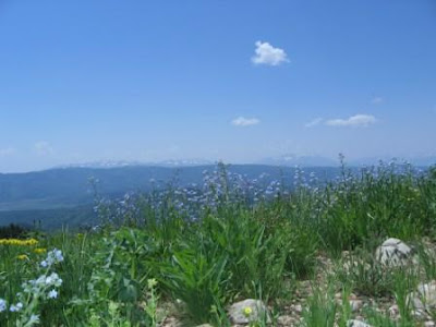
The path wound up and down hills, through an aspen forest graced with an abundance of wildflowers - knee high, in many places. The blooms were predominantly bluebells and forget me nots, with some columbines and, in areas along the creeks, yellow flowers I can’t put a name to covered the area to make the stream banks appear to be painted yellow. We continued past the 3 mile Sleepy Hollow trail to Red Ledge, a series of sheer rock cliffs. The trail there offered amazing views of both the Wasatch (Timpanogas and Twin Peaks were easily identifiable) and the Uintas.


We had plenty of water for Daisy and the horses, and some snowbanks up high for Daisy to wallow in. The only other person we saw was a lone motorcycle rider on the upper part of the trail – apparently that area allows ATV and motorcycle traffic. We returned to the trailer along the same beautiful path. The ride ended up being 12 miles, 2400 feet elevation gain, accomplished in under 3 hours riding time. According to the GPS, we travel at 3 to 3.5 mph at a walk, 7 or so at a trot, and 12-13 at a canter.
At the trailer, we allowed the horses to graze for a couple of hours while we hung out under the trees. We had found a reasonable campsite, but we decided to move to the area of the next day’s trailhead to save time in the morning. We went back to highway 40 and drove a few miles toward Heber, taking the Strawberry River turnoff to the north. From there, we drove maybe 5 miles along the gravel road to some corrals on the left. This is the campsite the AERC uses. The Strawberry River is easily accessible for horse water, there is adequate grass down along the creek, and the entire area is flat and large enough for many trailers. There was one other trailer parked by the corrals, but we pulled up a couple of hundred yards away.
Thursday morning, we rode the Mill B Flat trailhead. Again, the wildflowers were fantastic, thick and high all along the hilly aspen grove trail. We saw geraniums, columbine, and bluebells, forget me nots, and others. A couple of fallen tree trunks suitable for easy jumps lay across the trail we trotted and cantered along. We had a major glitch when one of Boss’s rear Easy Boot Bares came off and ripped the gaiter.

It wasn’t completely ruined, so Steve stopped and sewed the gaiter back on with the trusty awl that he carries in his saddlebags. We tightened the rear boots a notch, hoping that would solve the problem. It did, until later when he threw a front boot. We tightened those, too, and were able to complete the ride without more problems. Boss had new boots, which tend to gradually loosen for the first few rides. We’ll keep a closer eye on boot fit from now on.
Continuing along the trail, we left the trees behind and climbed to alpine tundra. The view was great, with the Wasatch mountains even closer and clearer than on the Red Ledge ride.

Our destination was Current Creek Peak, at about 10,500. The horses took us all but the last couple of hundred feet. There, it became too steep for them, so Steve and I tied them to convenient fence rails and walked up ourselves to shoot a few photos and admire the view. Down below, the grassy meadows looked as smooth and groomed as a golf course. And on the horizon, the mountains loomed.

We descended the Peak, mounted up, and continued on around Current Creek Peak, picking up a trail on the other side. We planned on a loop ride, taking a parallel trail to the morning path, but a few miles farther north. That worked out fine until we came to some deep snowbanks with boggy areas around them. We went around whenever possible. The meadows were pretty, and we found a dirt road to travel part of the way, but that dwindled to a trail and then the trail petered out completely. We did find the pass we were supposed to go over, and discovered another trail that lasted for awhile. We were maybe 5 miles from our camp when we discovered that we were on the wrong side of Mill B Creek with a big gorge between us and where we needed to be. Uh-oh.
I wasn’t about to risk my Mischief’s safety going down that thing, so I was relieved when Steve didn’t seem too keen on making the transit, either. We went back the way we had come and found another route across that was much safer. Unfortunately, the trail still wasn’t apparent on the other side. The GPS said where a trail was supposed to be, but that went through a spruce forest with lots of blowdown and spruce limbs scratching up our limbs. Not fun.
We reversed course, went upstream a little ways, and found an aspen grove that was much easier to traverse. In one of the small meadows full of grass and bluebells, we spotted about 4 bull elk, with their antlers still in velvet, maybe a hundred yards away. They saw us and melted into the forest. Daisy, of course, tried to chase them but came back when we called.
With all of the greenery on the forest floor, it was hard for the horses to see what they were stepping on in the aspens, although we were able to follow an elk trail part of the way. We came into an open meadow. There, the damp greenery on rocks was sometimes slick.
I was getting a little worried that Steve didn’t know where he was going. My GPS had run out of battery juice, so I didn’t have any little arrows to follow. It was 4PM or later by then, and we were still wandering. I should have had more faith, I guess. We eventually met up with the trail we had started out on, only a few miles from our trailer. Whew. I was relieved. I’m pretty sure Steve was relieved. Mischief was loving being back on the trail. Steve rode Boss back into the forest once more, looking for where our loop trail was supposed to meet the one we were on, according to his map. He didn’t find even a sign of a trail. It must have once existed, since it was on a map, but those Topo! Maps are sometimes outdated. Apparently the forest service had decided that loop trail was too much trouble to maintain and has let it return to nature. As we saw, to a greater extent than was entirely pleasant.
Anyway, we know now. We might try a loop again, but we’ll choose our own trail, higher up, through mostly open meadows.
We got back to the trailer a little after 5, after 8 hours of travel, boot fixing, and picture taking. Overall, in spite of the glitches, it was a beautiful day. Total ride was 16 miles, with 3300 feet elevation gain.

Conclusion: We will definitely go back to this area at least once a month through fall. The wildflowers and views are unbeatable. Can’t wait to see what’s blooming next time. This place is like miles and miles of Albion Basin, the wildflower haven near Alta that attracts tourists from all over the world.


 Last weekend, the aspens were near their peak autumn colors. We rode the horses from a trailhead at 8800 feet (2700 m) to a viewpoint at 10,100 feet (3100 m).
 The air was hazy, perhaps due to smoke from a fire somewhere, but you can see the Wasatch mountains in the distance. You can see patches of aspen gold on the hills. (Click to enlarge.)
 We saw the occasional maple tree, dressed in red.
 Perhaps 75 % of the aspen above 9000 feet have turned gold.
 This little pond provided a nice swim for Daisy.
 Between the trees, you can see Currant Creek Peak.
 ...all the way back to the trailer, also wreathed in gold.
 This past weekend, we again visited the area north of Strawberry Reservoir. On Saturday morning, we drove up Co-op Creek road about 12 miles to Roundy Basin, at the northwest foot of Current Creek Peak. We arrived about 10 AM and were ready to ride by 11. We heard gunshots coming from not too far from the trailer and assumed the hunters were out siting in their guns before hunting season starts. Coyotes yipped in the distance, perhaps disturbed by, or protesting against, the guns.
 Again, the folks were friendly, pointing us in the direction of the spring. When we didn’t find a pool right away, they came up to show us the spot and stayed to chat. The man was from Heber and volunteered that his grandfather had had a cabin nearby in the 30’s, and his family had been coming there ever since. With his family ties to the area, we were pleasantly surprised that he wasn’t possessive, but quite willing to share information on the spring and the trails.
 The AERC (American Endurance Ride Conference) has an annual event in the Uinta National Forest north of Strawberry Reservoir in mid-June, called Strawberry Fields Forever. We have an interest in attending some year, maybe competing in a 25 mile ride, but we missed out again this summer. Since the ride photos looked spectacular, we decided to check out the area on our own.
 The path wound up and down hills, through an aspen forest graced with an abundance of wildflowers - knee high, in many places. The blooms were predominantly bluebells and forget me nots, with some columbines and, in areas along the creeks, yellow flowers I can’t put a name to covered the area to make the stream banks appear to be painted yellow. We continued past the 3 mile Sleepy Hollow trail to Red Ledge, a series of sheer rock cliffs. The trail there offered amazing views of both the Wasatch (Timpanogas and Twin Peaks were easily identifiable) and the Uintas.

 It wasn’t completely ruined, so Steve stopped and sewed the gaiter back on with the trusty awl that he carries in his saddlebags. We tightened the rear boots a notch, hoping that would solve the problem. It did, until later when he threw a front boot. We tightened those, too, and were able to complete the ride without more problems. Boss had new boots, which tend to gradually loosen for the first few rides. We’ll keep a closer eye on boot fit from now on.
 Our destination was Current Creek Peak, at about 10,500. The horses took us all but the last couple of hundred feet. There, it became too steep for them, so Steve and I tied them to convenient fence rails and walked up ourselves to shoot a few photos and admire the view. Down below, the grassy meadows looked as smooth and groomed as a golf course. And on the horizon, the mountains loomed.
 Conclusion: We will definitely go back to this area at least once a month through fall. The wildflowers and views are unbeatable. Can’t wait to see what’s blooming next time. This place is like miles and miles of Albion Basin, the wildflower haven near Alta that attracts tourists from all over the world.


