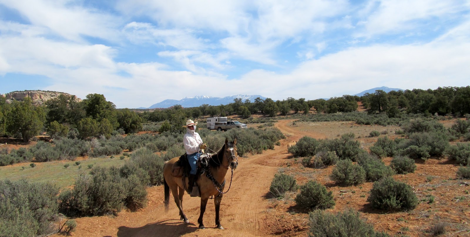
Our last ride in Capitol Reef country was to Stud Horse Peaks, shown above. The highest is 7000 ft in altitude. This area is west of the park boundary, so Daisy was allowed to run with us. She was quite pleased.
The name of the peaks may have originated because of wild horse herds that once lived in the area. Legend has it that a stallion would stand on the peaks and keep guard over his mares. Frankly, this seems unlikely since the "peaks", which are actually more like mesas, are a couple of hundred feet above the valley floor, a long way for the stallion to travel away from the herd, and a long rumble downhill over rocky terrain if he actually saw danger and needed to race to the rescue.
We found this structure not far from our trailhead. If it's for sale or rent, are you interested? A little work might be required before you move in, but it could keep the rain off (if you're lucky). Daisy approves!
Need a new truck cab? This one's available. Spare tire included, and zero carbon emissions guaranteed. A running board was lying a hundred yards away. Maybe a little looking would turn up enough to piece this baby together and take her for a spin.
Apparently, an "adit" mine (horizontal mine shaft) is up on these mountains somewhere, according to the USGS maps. This explains why someone went to the trouble of carving out a road.
The old road is now abandoned and the mountainside is slowly but surely taking it back.
The washout depicted here is only the beginning. In places, huge boulders had fallen across the road bed.
We rode as high as we could and were rewarded with a fine view of the reddish Circle Cliffs, and past them all the way to Boulder Mountain.
Here's a view of Boulder Mountain (11,330 ft) framed by tree branches. It's about 30 miles away.
Returning to the trailhead, we realized that we'd had a pretty fine view, even from our parking spot. That's what I love about the western U.S.. The views are good nearly everywhere!
Showing posts with label Capitol Reef. Show all posts
May 2, 2013
May 1, 2013
Desert Camp
We camped next to an old, ramshackle cowboy corral on BLM land outside Capitol Reef. The corral was good enough to hold our boys, and roomy enough so they could eat, roll, and lie down whenever they wished.
The post-sunset colors are always unique.
In the light of the full moon, we could easily see what the horses were up to, even in the middle of the night.
Apparently, just hanging around scratching various itches was a nice break for them.
After a night with the freedom to rock and roll, Boss had a serious bad tail-hair morning.
The post-sunset colors are always unique.
In the light of the full moon, we could easily see what the horses were up to, even in the middle of the night.
Apparently, just hanging around scratching various itches was a nice break for them.
After a night with the freedom to rock and roll, Boss had a serious bad tail-hair morning.
April 30, 2013
Desert Blooms
| Claret Cup Cactus |
| Indian Paintbrush |
| Globemallow |
| Utah Penstemon |
| Penstemon |
| Primrose |
| Fremont's Mahonia |
| Utah Serviceberry |
| tasty bunch grass |
| Milkvetch? |
April 29, 2013
Through the Narrows
Within the Muley Twist, the sandstone cliffs form narrow, winding sections, enough to "twist a mule", they say. The horses weren't too stressed, though. They did get a little excited when we came upon a hiker, but only until they figured out he was just a puny human wearing a backpack. Not an alien after all.
In such narrow confines, the main danger would be a flash flood. A rain storm as much as 50 miles away could result in a tremendous rush of water through this canyon.
Here, you can see the high water mark, shown by debris around a cottonwood tree trunk. It's higher than the top of Steve's hat. We checked the weather report before leaving home, and no rain was in the forecast.
Notice the position of Boss's muzzle. He's resting it on Steve's arm. That seems like a very sweet gesture on Boss's part. But maybe he's just hoping he'll get a treat! (BTW, that's a homemade GPS holder on Steve's hip, not a gun holster!)
Where the canyon spread out, we found plenty of bunch grass. In spite of the good grazing, no deer or antelope signs were apparent. Maybe there's not enough water to support them.
We found a few "waterpocket" pools. The horses were pleased at the discovery because the day was warm.
In the middle of the above photo, you can see one of the many alcoves in the canyon. No doubt they would be fun to explore.
Next post, I'll show you some of the wildflowers we found thriving in this desert ecosystem.
In such narrow confines, the main danger would be a flash flood. A rain storm as much as 50 miles away could result in a tremendous rush of water through this canyon.
Here, you can see the high water mark, shown by debris around a cottonwood tree trunk. It's higher than the top of Steve's hat. We checked the weather report before leaving home, and no rain was in the forecast.
Notice the position of Boss's muzzle. He's resting it on Steve's arm. That seems like a very sweet gesture on Boss's part. But maybe he's just hoping he'll get a treat! (BTW, that's a homemade GPS holder on Steve's hip, not a gun holster!)
Where the canyon spread out, we found plenty of bunch grass. In spite of the good grazing, no deer or antelope signs were apparent. Maybe there's not enough water to support them.
We found a few "waterpocket" pools. The horses were pleased at the discovery because the day was warm.
In the middle of the above photo, you can see one of the many alcoves in the canyon. No doubt they would be fun to explore.
Next post, I'll show you some of the wildflowers we found thriving in this desert ecosystem.
April 28, 2013
Lower Muley Twist
We trekked down to Capitol Reef National Park last week, horses in tow. Above is a view of the Henry Mountains from the Notom Road / Burr Trail heading south from Hanksville, Utah.
We drove along the eastern border of the Park, with the Henry Mountains to the east and Capitol Reef's Waterpocket Fold to the west.
The Waterpocket Fold is a nearly 100-mile long warp in the Earth's crust. The rock layers on the west side of the Fold have been lifted more than 7000 feet (2100 m) higher than the layers on the east. The Fold was formed between 50 and 70 million years ago when a fault beneath the area moved. Overlying rock layers were pushed up and formed a monocline.
More recent uplift of the entire Colorado Plateau and the resulting erosion has exposed this fold at the surface. Shallow basins are formed in the sandstone layers as they are eroded by water. These basins are common throughout this Fold formation, capturing water from snowmelt and rain. Because of these eroded "waterpockets", the Fold earned its name.
Our trail began at "The Post". Originally, the Post was an old cottonwood tree to which cowboys hitched their horses while traveling the Burr Trail. The tree is long gone. Now there's just a trailhead parking area and an old corral. The corral was built by local ranchers in 1950 and used for spring and fall cattle drives. Although still usable in part, most of the corral is now in disrepair.
Poor Daisy had to stay at the trailhead (dogs not allowed on national park trails), but she was happy enough in the shade with a bucket of water.
Steve and I saddled up and rode south on a sandy path parallel to the Waterpocket Fold. No vehicles or bikes are allowed here. We saw only three hikers over 45 miles and 2 days of riding, so it's a great area for solitude and communing with the desert environment.
These are the Muley Tanks, examples of waterpockets in the Waterpocket Fold. Note the two pools, a beautiful sight in this dry land, showing the sandstone pour-off above. We saw tadpoles and bugs in the water and a toad plopping into the lower pool.
Steve climbed above the pools to get this photo. I'm holding Boss below. Coco is getting antsy. "Come back, Coco! We're not ready to go yet."
Four miles down the Post trail, we reach the entrance to Lower Muley Twist Canyon. From 1881 to 1884, the canyon served as a wagon route for Mormon pioneers traveling from northern Utah toward San Juan County in the southernmost part of the state. The canyon was said to be narrow enough to "twist a mule", the origin of the unusual name.
As we are swallowed up by the deep shadows of the looming sandstone cliffs, we feel like we're entering a worm hole to alternate universe. Cowboys and Aliens, here we come.
To be continued...
We drove along the eastern border of the Park, with the Henry Mountains to the east and Capitol Reef's Waterpocket Fold to the west.
The Waterpocket Fold is a nearly 100-mile long warp in the Earth's crust. The rock layers on the west side of the Fold have been lifted more than 7000 feet (2100 m) higher than the layers on the east. The Fold was formed between 50 and 70 million years ago when a fault beneath the area moved. Overlying rock layers were pushed up and formed a monocline.
More recent uplift of the entire Colorado Plateau and the resulting erosion has exposed this fold at the surface. Shallow basins are formed in the sandstone layers as they are eroded by water. These basins are common throughout this Fold formation, capturing water from snowmelt and rain. Because of these eroded "waterpockets", the Fold earned its name.
Our trail began at "The Post". Originally, the Post was an old cottonwood tree to which cowboys hitched their horses while traveling the Burr Trail. The tree is long gone. Now there's just a trailhead parking area and an old corral. The corral was built by local ranchers in 1950 and used for spring and fall cattle drives. Although still usable in part, most of the corral is now in disrepair.
Poor Daisy had to stay at the trailhead (dogs not allowed on national park trails), but she was happy enough in the shade with a bucket of water.
Steve and I saddled up and rode south on a sandy path parallel to the Waterpocket Fold. No vehicles or bikes are allowed here. We saw only three hikers over 45 miles and 2 days of riding, so it's a great area for solitude and communing with the desert environment.
We rode over red sand formed by erosion of the Carmel formation
with no shortage of interesting sandstone cliffs to admire. These are the Muley Tanks, examples of waterpockets in the Waterpocket Fold. Note the two pools, a beautiful sight in this dry land, showing the sandstone pour-off above. We saw tadpoles and bugs in the water and a toad plopping into the lower pool.
Steve climbed above the pools to get this photo. I'm holding Boss below. Coco is getting antsy. "Come back, Coco! We're not ready to go yet."
Four miles down the Post trail, we reach the entrance to Lower Muley Twist Canyon. From 1881 to 1884, the canyon served as a wagon route for Mormon pioneers traveling from northern Utah toward San Juan County in the southernmost part of the state. The canyon was said to be narrow enough to "twist a mule", the origin of the unusual name.
As we are swallowed up by the deep shadows of the looming sandstone cliffs, we feel like we're entering a worm hole to alternate universe. Cowboys and Aliens, here we come.
To be continued...
March 15, 2009
Capitol Reef
Our campsite last week had this view of the Henry Mountains to the east.
To the west lay the terrain of Capitol Reef National Park - so called because of the white, rock domes seen in the area.
Our ride into Capitol Reef started at a remote hikers' trailhead on the eastern side of the park, not far from Sandy Ranch. The sign shown below was unnecessary. No way any vehicle was going past this point. The terrain was just too rough.
The trail was poorly marked at first, and not marked at all after a few hundred yards. We ended up going up and down canyons, some steep and rocky, along and through a creek, finally reaching the Waterpocket Fold, the backbone of Capitol Reef.
Here it is up close and personal. That's snow you see in the crevices on the shady side of the canyon.
A surprise and highlight of the trip was this cave (Steve is standing in the entryway):

This one was even larger than Cowboy Cave. Although an archeology site sign was present, we found no other direct information, either there or online later. The Park Service site mentions that people of the Fremont culture lived in the area from 900 AD to about 1500 AD. Presumably, this cave (maybe we should call it an overhang, since it's only about 40 feet deep) was inhabited then.
Here it is up close and personal. That's snow you see in the crevices on the shady side of the canyon.
This one was even larger than Cowboy Cave. Although an archeology site sign was present, we found no other direct information, either there or online later. The Park Service site mentions that people of the Fremont culture lived in the area from 900 AD to about 1500 AD. Presumably, this cave (maybe we should call it an overhang, since it's only about 40 feet deep) was inhabited then.
This rock found under the overhang shelter shows signs of having been used as a grinding stone. The smaller dark pieces are potshards.

Tiny corncobs (the glove is there to show size) were scattered about in the cave:
Subscribe to:
Posts (Atom)