May 29, 2018

Thunder Mountain

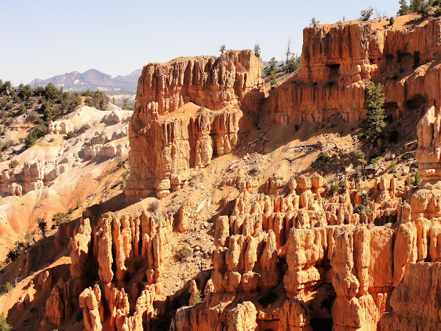
Thunder Mountain is a popular bike and horseback riding trail in Red Canyon.
It has many beautiful red-orange rock formation,
and pinnacles similar to those found in Bryce Canyon National Park.
Although it's dry land with relatively sparse vegetation, a lot of tree varieties grow there.
Limber Pine
Bristlecone Pine
Besides limber and bristlecone pines that grow on dry, windy passes at about 8000 feet, there are also Ponderosa and pinyon pine.
This Gray Jay, also known as a Camp Robber Jay, is resting on a limber pine in a high pass.  These birds are known for hovering around camps, looking for crumbs, sometimes snatching them right out of a person's hand.
In a spot with hitching rails, designed for riders to take a break, we found this tourist outhouse.  The lack of door seems a bit inconvenient.
The great views made our 9 mile round trip well worth the effort.  

May 28, 2018

Red Canyon Trail

In mid-May, we made a 2 day trip down to Red Canyon, near Bryce Canyon National Park, just in time to see new leaves on the aspens.
Almost a trail
Steve had a new trail mapped out.  It was clear on the topo maps, but mostly hidden by trees on Google Earth, so we weren't sure how it would go.  Much of the trail was invisible, but as long as the forest undergrowth was clear, we were able to go in the right direction.
We finally climbed above the forest and reached a plateau.
Up high, the few trees grew sideways, a sign of a persistent wind.  From the plateau we headed toward Casto Butte, then found a forest trail traveling around it and down the other side.
There were a few obstacles that required some workarounds.
Judd Spring
The horses were glad to reach Judd Spring for a cool drink.
We encountered a few spots where the trail was blocked, but we were able to find a way around.  
Looking back after passing all the timber and reaching a civilized two-track, we could see Casto Butte in the distance.  We had traveled up one side, around it, and down the other side for about a 20 mile ride.

May 8, 2018

Corner Canyon

There are several Corner Canyon trailheads within a few miles of our house.  We go there for a training ride along upper Corner Canyon road, about 12 miles and 2400 feet of elevation gain.
You can see the "road" above. It's rutted and rocky in places and would be challenging for a 4 wheeler.  We've never seen a vehicle up there, although we usually see bikers and sometimes hikers.
At first the horses were scared of bikes, but they have adapted to a more urban environment and all that goes with trails near the city.
At the upper end of our ride, we looked out across the mountain vista and saw some white dots. 
With the camera zoom, a small herd of mountain goats became visible.  
Closer still, and you can see the goat's horns.
Salsa is sporting her new saddle as she looks out over the scenery.
Behind Steve and Salsa is the 11000 ft Box Elder Peak, still snow-covered down to about 9000 feet.

Family in Seattle

Mt. Ranier in the distance
We recently went to Seattle to meet our newest grandbaby.
Our son seems to fully enjoy his busy dad time, with one 22 month toddler, and the other baby only 2 months.
We went on several hikes.  It's good to start the kids early!
While touring around Union Bay Natural Area, a heron hid in tall grass near a pond. 
kildeer
killdeer flopping
killdeer nest
A kildeer did her best to distract us from her nest, flopping around on the ground as if injured to attract our attention. 
An osprey pair had not yet built their nest, but we spotted them roosting in the trees.  
Another day, we visited Discovery Park. We hiked along the shore of Puget Sound and saw lots of shore birds and the West Point Lighthouse, shown above.  It began operating in 1881, the first manned lighthouse on Puget Sound. Its alternating red and white flashing signal was first operated by a kerosene lamp.  It was attached to the Seattle electric grid in 1926, and became automated in 1985.  The white flash is visible for 15 nautical miles, and the red flash is visible for 13 nautical miles.  It is fenced off and apparently not open to visitor tours.
There were some huge yachts traveling through the Sound.  We speculated on which Seattle billionaire might own each of them.

February 22, 2018

Warm before Storm

With a storm in the forecast, we took advantage of a beautiful Saturday to ride Antelope Island.
We started at White Rocks Bay and rode a 27 mile loop around the island, with 3100 feet of altitude gain and loss.
We saw a small herd of bighorn sheep.  We knew the sheep live on the island, but we had not seen them before.
Salsa was on high alert, looking at those sheep. She was convinced that they were about to attack at any moment.
On the east side of the island, we passed rock formations that have been shaped and smoothed by thousands of years of erosion caused by wind, sand, and perhaps wave action from the lake. The rocks are at least 100 yards from the shoreline now.
The lake level has been as much as 20 feet higher in the records kept since the Mormon pioneers arrived in 1847.  The Great Salt Lake volume is down about 50% over 180 years.  Today, 50% of the water that used to feed the lake is now diverted for agricultural irrigation, of which about 10% is used for watering lawns and other human use. Some of the decrease may be due to global warming and less rainfall. In any case, one wonders what will be left in another 100 years.
The Sentry is the name of the mountain behind Steve and Salsa.  It does seem to be standing guard.  The snow-capped peaks in the distance are the Oquirrh Range, which runs N-S on the western side of the Salt Lake valley.
As we completed the loop on the other side of the island, we saw quite a few buffalo in small groups, grazing on the winter grass. When we were within sight of our trailer, 2 buffalo crossed the parking lot, weaving through cars and trailers.  They acted like the owned the place -- and they can feel pretty confident that no horse or human will challenge their rights.
It was a great day for all critters everywhere.
We chose a good day, because the next morning, this was the view out the kitchen window!

February 7, 2018

Spring in February?


2500 feet above our trailhead in Corner Canyon
Even though I haven't been posting, we haven't stopped riding.  We rode in the neighborhood and in Dimple Dell through most of the winter.  Steve has a new horse, Salsa, shown above. Salsa is wearing Easyboot Gloves, which are like running boots for a horse.
Mt. Timpanogas in the background
For the past couple of weeks, we've been riding Corner Canyon, gradually increasing our altitude as the snow melts.  As of today, the trails are snow-free up to 6900 feet on the southwest facing slopes.  That allows us to make a 12 mile round trip with a total altitude gain and loss of about 2500 feet.  A fine workout!


Utah Lake in background
It has been a great winter for riding😊, but maybe not so great for skiing. 😕

LinkWithin

Blog Widget by LinkWithin