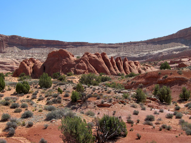
We drove along the eastern border of the Park, with the Henry Mountains to the east and Capitol Reef's Waterpocket Fold to the west.
The Waterpocket Fold is a nearly 100-mile long warp in the Earth's crust. The rock layers on the west side of the Fold have been lifted more than 7000 feet (2100 m) higher than the layers on the east. The Fold was formed between 50 and 70 million years ago when a fault beneath the area moved. Overlying rock layers were pushed up and formed a monocline.
More recent uplift of the entire Colorado Plateau and the resulting erosion has exposed this fold at the surface. Shallow basins are formed in the sandstone layers as they are eroded by water. These basins are common throughout this Fold formation, capturing water from snowmelt and rain. Because of these eroded "waterpockets", the Fold earned its name.
Our trail began at "The Post". Originally, the Post was an old cottonwood tree to which cowboys hitched their horses while traveling the Burr Trail. The tree is long gone. Now there's just a trailhead parking area and an old corral. The corral was built by local ranchers in 1950 and used for spring and fall cattle drives. Although still usable in part, most of the corral is now in disrepair.
Poor Daisy had to stay at the trailhead (dogs not allowed on national park trails), but she was happy enough in the shade with a bucket of water.
Steve and I saddled up and rode south on a sandy path parallel to the Waterpocket Fold. No vehicles or bikes are allowed here. We saw only three hikers over 45 miles and 2 days of riding, so it's a great area for solitude and communing with the desert environment.
We rode over red sand formed by erosion of the Carmel formation
with no shortage of interesting sandstone cliffs to admire. These are the Muley Tanks, examples of waterpockets in the Waterpocket Fold. Note the two pools, a beautiful sight in this dry land, showing the sandstone pour-off above. We saw tadpoles and bugs in the water and a toad plopping into the lower pool.
Steve climbed above the pools to get this photo. I'm holding Boss below. Coco is getting antsy. "Come back, Coco! We're not ready to go yet."
Four miles down the Post trail, we reach the entrance to Lower Muley Twist Canyon. From 1881 to 1884, the canyon served as a wagon route for Mormon pioneers traveling from northern Utah toward San Juan County in the southernmost part of the state. The canyon was said to be narrow enough to "twist a mule", the origin of the unusual name.
As we are swallowed up by the deep shadows of the looming sandstone cliffs, we feel like we're entering a worm hole to alternate universe. Cowboys and Aliens, here we come.
To be continued...


Oh how interesting, Janie. I love reading all of this history and I can only imagine how wonderful it is experiencing it firsthand.
ReplyDeleteWe 'skirted' Capitol Reef in 2011 when we were on Scenic Highway 24.... Gorgeous area.
Thanks for sharing. Can't wait to see and hear more. Love the word, "Muley Twist"...
Hugs,
Betsy
Fascinating formations and rich red sand color. I wonder what you saw next!
ReplyDeleteA National Park whose name I was unfamiliar with. And another reason to head southwest to Utah...:)
ReplyDeleteJanie, I'm benefitting from your knowledge of geology. We're in UT! Staying at a motel right by the river in Green River. Left the house this AM with icicles hanging off the eaves and biked the CO Nat'l Monument in 80 degrees! Passed a lot of big horse trailers coming West on 70. I'm already enjoying the desert canyons of UT. On to Zion in AM.
ReplyDeleteThis is definitely fantastic country. The beauty is amazing, and your photos are wonderful. I'm glad you could take us along with you on the trail, even if Daisy had to wait at the trailhead.
ReplyDeleteMagnificent views of the wild west. I love the facts and history of the areas you roam.
ReplyDeleteYou have covered some beautiful territory! "No vehicles or bikes are allowed here" sounds good to me. We have had some near head on collisions with bikers while on some trails.
ReplyDeleteI hope you don't have to twist too hard through that narrow canyon.
ReplyDeleteGorgeous desert scenery and such an interesting post. I can only imagine what a welcome sight those pools of water must have been to those early explorers.
ReplyDeleteyou are watching sea sand and enjoying horse riding.very nice
ReplyDeleteI enjoyed reading about how the land was formed so many million years ago. It certainly makes a wonderful place to explore on horseback.
ReplyDeletefun ride today. My dad worked a lot in this area so the names are familiar to me. I have never been there myself so it was fun to see your pictures and put images to my dad's words.
ReplyDeleteGorgeous panorama shots; I love the different colors of rock and dirt. Neat-looking corral, even if it's in poor repair. Another wonderful ride. Too bad Daisy had to stay behind.
ReplyDelete~Lindy
What an interesting post, Janie, I love the history.
ReplyDeleteHowever, I see a country that looked like it couldn't decide what to be! But it is all unique and beautiful.
Cheers,
Jo
Janie, you travel paths that I would never ever take, but am so thoroughly enjoying all you share. It is both educational & enjoyable to see all you visit. Exquisite countryside trails, landscapes & the pictures are breathtaking. TY for bringing to me what I'd never see otherwise.
ReplyDeleteTTFN ~
Marydon