We have 8 inches of snow this morning, the first major storm of the season. Still snowing.
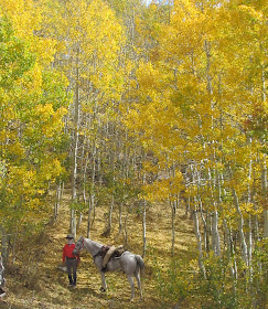
This is our new horse, a six year old Arabian mare. We call her Sugar. She's a sweetheart.
Here's another little sweetheart in our lives, a brand new grandbaby! She's #7.
Grandpa is pleased.
Happy Christmas, everyone! May your days be merry and bright, or snowy, whichever you prefer.
Pages
▼
December 14, 2015
October 12, 2015
Water is the Desert's Gem
 |
| On the rim, Horseshoe Canyon. The Great Gallery is about 5 miles down the canyon |
 |
| Faint trail crosses the arid landscape |
From the air, the bends in the Green River create what looks like the rowels (points) of a spur.
 |
| One of the rowels of the Spur as seen from the Moab (east) side of the Green River |
As we neared southernmost rowel of the Spur, the horses were ready for a drink.
 |
| Light Green Tree Marks Water |
 |
| Desert Gem |
 |
| view of Green River from the Spur (west side of the river) |
Boss looked at one of the potholes, then at me, as if to say, "How the heck do you expect me to go swimming in this?"
Some of the potholes were more sizeable, but not deep enough for Boss to get his belly wet.
Some areas have good grass. No cows graze on the Spur, and even the burros don't venture out there very often, possibly because the water holes are so scarce.
We did see quite a few jackrabbits, and as we explored a small canyon, we surprised a large owl, probably a Great Horned Owl, which are said to be fairly common in the Canyonlands. The land between Horseshoe Canyon and the Green River, known as The Spur, encompasses well over 50 square miles. All of it is nearly untouched, lonely and wild.
September 29, 2015
Painted Landscape
Last weekend, the aspens were in their peak autumn finery. Most turn gold, but some sport a fashionable auburn color.
As we climbed the hills north of Strawberry Reservoir, we looked down upon meadows bordered by aspen and spruce. (You can see the reservoir at the top of the photo.)
Aspen gold is particularly beautiful when backlit by the sun.
Medallion leaves cover this aspen lined trail.
The forest dwarfs a horse and rider, making us realize how small we are compared to nature's vast beauty.
September 23, 2015
Early Autumn Colors
On the trails north of Strawberry Reservoir, the aspens are starting to change. The elk mating season has begun, and the bulls announce their presence with bugling. The small herd we spotted didn't hang around long enough to be photographed.
Daisy has a grand time sniffing for elk and running with her horses.
On Tibble Fork, maple reds dominate in the higher terrain, with Timpanogas in the background.
while narrow leaf cottonwoods and box elder begin to change along the stream.
Daisy has a grand time sniffing for elk and running with her horses.
On Tibble Fork, maple reds dominate in the higher terrain, with Timpanogas in the background.
while narrow leaf cottonwoods and box elder begin to change along the stream.
Steve and Coco in Tibble Fork
Autumn colors dress the mountains in splendor. Another week, and colors will be at their prime.August 2, 2015
Shingle Creek and Tibble Fork
In places, the grass and flowers were head high as we rode along the trail.
Boss found some tasty thistle to enjoy. He bites off the flowers very carefully to avoid the prickly leaves.
From the highest point on the Ridge Trail (10,000 ft), we had a view of Deer Creek Reservoir and Heber City, 4000 ft below
Much of the trail was forested, but the mountain views were spectacular in any open area.
One downside for horsemen: motorcycles are allowed on some of these trails. At one point, a motorcycle came skidding down a hill and screeched to a halt just in front of Coco. Luckily, Coco had the good sense to stand stock still, just watching the show. Another horse might get a teensy bit excited.
We plan to go back soon and explore other trail possibilities. Good news for Daisy - dogs are allowed. We'll bring her next time.
July 20, 2015
Exercise Run
One of our sons wanted a real hike during his visit. Here he is climbing above the city on the Cherry Canyon Trail.
We cheated and rode our horses for the 4400 feet of altitude gain.
The wildflowers were spectacular.
It's a tiny columbine, called a Shooting Star Columbine, Aquilegia elegantula. We had never seen one growing in the wild before. Nature is a wonder, always providing something new.
We cheated and rode our horses for the 4400 feet of altitude gain.
The wildflowers were spectacular.
We rode/hiked all the way to just below the rocky cliffs of Lone Peak.
On another day, we rode in Box Elder canyon in the Stansbury Mountains and found this little gem.It's a tiny columbine, called a Shooting Star Columbine, Aquilegia elegantula. We had never seen one growing in the wild before. Nature is a wonder, always providing something new.
July 19, 2015
Fun with Family
We've had a busy summer so far, highlighted by a visit with kids and grandkids.
We hiked.
Took lots of photos.
Went fishing,
Played some basketball.
And bonded around the barn. The grandkids seemed to enjoy doing a few farm chores, riding on Mischief, and feeding treats to Boss and Coco.
Fortunately, our new house is roomy enough for all, with the great outdoors providing plenty of activities.
 |
| White Pine, Little Cottonwood Canyon |
 |
| white pine, Little Cottonwood Canyon |
 |
| Hike to The Notch, off Mirror Lake highway |
 |
| Lunch at The Notch |
 |
| Janie and Steve, The Notch |
 |
| Provo River, Mirror Lake Highway |
Played some basketball.
Fortunately, our new house is roomy enough for all, with the great outdoors providing plenty of activities.
June 6, 2015
New Home, New Trails
We've been busy exploring the many trails available in the Salt Lake Valley.
A favorite is the trail shown in blue on google earth. The steep part is Cherry Canyon, which begins at the Orson Smith trailhead. The lower portion is the Bonneville Shoreline Trail, which continues south for many miles.
Cherry Canyon gains about 4000 feet of altitude in 4 miles, going all the way up the mountain to the base of Lone Peak.
It's a fantastic ride with great views of the mountains and the Salt Lake valley.
In the panorama above, you can see Utah Lake on the right, and the Wasatch Mountains on the left.
We stopped when we reached snow, at about 9100 feet. The stream shown above comes from melting snow.
The water was clear and cold, just the way a thirsty horse likes it.
Flowers are blooming on the mountain. A bank of orange poppies attracted out attention.
Near the trailhead, the grass is tall from all the rain we had in May.
Since we've been city folk, the horses have learned to tolerate walkers, joggers, hikers with backpacks, bikers, and an assortment of dogs.
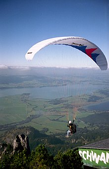
 One morning, as we traveled up the Cherry Creek trail, a dozen paragliders swooped down the mountain and passed about 10 feet over our heads. Boss got a little freaky over that, but he got over it when he found that the big sails and whoo-whooing adventurers were not going to eat him. (The photo above came from Wikipedia. We were way too busy keeping the horses from running down the mountain to take any photos of the actual event.
A favorite is the trail shown in blue on google earth. The steep part is Cherry Canyon, which begins at the Orson Smith trailhead. The lower portion is the Bonneville Shoreline Trail, which continues south for many miles.
Cherry Canyon gains about 4000 feet of altitude in 4 miles, going all the way up the mountain to the base of Lone Peak.
It's a fantastic ride with great views of the mountains and the Salt Lake valley.
In the panorama above, you can see Utah Lake on the right, and the Wasatch Mountains on the left.
We stopped when we reached snow, at about 9100 feet. The stream shown above comes from melting snow.
The water was clear and cold, just the way a thirsty horse likes it.
Flowers are blooming on the mountain. A bank of orange poppies attracted out attention.
Near the trailhead, the grass is tall from all the rain we had in May.
Since we've been city folk, the horses have learned to tolerate walkers, joggers, hikers with backpacks, bikers, and an assortment of dogs.


