February 28, 2011

Canyonlands, Day 3, Goat Park

The original plan for Day 3 was to ride across the lower end of Horseshoe Canyon (outside the national park) and over to Cowboy Cave, described here
However, as anyone knows, the best laid plans of mice and men sometimes go awry, especially in canyon country.  The photo above may give a hint of the topography of the 750 foot drop into the canyon. Topo maps and even Google Earth don't really tell the whole story on cliffs.  Steve's planned route turned out to be all slickrock (Navajo standstone), and just too steep for a safe descent on horseback.  Actually, I'm not sure I would have been willing to do it on foot.
Steve studied the map and GPS, trying to come up with an alternative.  (Note his snazzy shemagh.  These are worn by Arabs and Kurds, who've been living with desert winds, sun and sand for centuries.  Steve read some books about the desert people and decided he needed his own shemagh.  Next time, I want one!) We rode along the rim for a ways, but we didn't find a route across the canyon.
On to Plan B. On the ride from our campsite, we had noticed an old road going up a meadow called Goat Park.  It turned out to provide some great riding. (I know I look like I gained about 50 pounds over the winter, but that's the burly down vest's fault.)
 We had views all the way to the Book Cliffs to the north, at least 60 miles away.
The "Red Nubs", aptly named, provided interesting views.
This monolith protruded out of the earth from the top of a little hill.  It dwarfed man and beast.
We found very little water, but a few patches of snow sustained Daisy.  We also had extra water to give her if necessary.  We found sandstone pocket water for the horses, but they weren't willing to drink much. 
Our lunch break was overlooking Blue John Canyon. Some of you may have heard the story of a hiker who was trapped by a boulder in a slot canyon and had to cut off his own arm with a pocket knife to save himself. A movie "127 Hours" was made about the incident that happened a few miles down this very canyon.

February 27, 2011

Canyonlands, Day 2, The Spur

After exiting the Horseshoe Canyon section of Canyonlands NP, we continued riding east on the old oil company road.  The LaSal Mountains, near Moab, were directly ahead, looking misty.  Our destination was The Spur, a mesa top with a number of lookout points that resemble the rowels of a spur from an aerial view. 
We found this old oil well site on our route, apparently the one for which the road across Horseshoe Canyon was built.  Steve is standing on the "bull wheel" with Sugarloaf Butte in the background.  Best I can tell, this wheel acted as part of the mechanism of pulleys and cables that rotated the drill pipe as the bit forced its way into the earth.  The men would pull out the pipe periodically and sharpen the drill bit by hand, apparently by hammering on it until it formed a point again.  The process was pretty primitive. 
The clean up was primitive as well.  The old drill rig (some of the beams are behind me on the left in the photo above) was never removed, and the skeleton remains in the sand, along with the old wheel, some huge cable spools, etc.  This seems a little reminiscent of the Shelley poem, "Ozymandias."
"Two vast and trunkless legs of stone
Stand in the desert. Near them on the sand,
Half sunk, a shattered visage lies...
...Round the decay
Of that colossal wreck, boundless and bare,
The lone and level sands stretch far away."

Not all of the leavings were wasted, though.  Just up the trail a little way, some enterprising ranchers built a corral out of salvaged cable.  Waste not, want not.  One man's trash is truly another man's treasure.
The view from the Spur was impressive.   The line of rock outcroppings in the photo outline Horseshoe Canyon, from which we came.  We continued along old two-tracks and cow trails, trying to find some springs Steve had seen on his topo map and marked on his GPS.  No luck there.  Either the springs are misplaced on the map, or they have dried up since the mapping was done. 
No matter.  We rode sandy trails on a nice day, and the views alone were worth the trip.  The above photo shows the distant LaSal Mountains.  In the foreground are Navajo sandstone domes, and slightly lower are the Wingate sandstone cliffs along the Green River Gorge.  The photo is taken from the vantage point of The Spur, about 600 feet higher than the surrounding desert of the Canyonlands Maze District. Geologists say that the Navajo sandstone was formed by an eolian (windblown) process about 180 million years ago.  Uplift and subsequent erosion about 15 million years ago exposed these formations, and since that time, further erosion formed the deep canyons. The Navajo sandstone domes resemble, and essentially are, fossilized sand dunes with their characteristic crossbedding.
If you would like to read about the history of this area, I recommend a couple of fascinating interviews with Ned Chaffin, a man whose family ranched there in the '20's and '30's.  Links to the interviews are posted on the the Canyonlands National Park site, and I include them here:
http://www.nps.gov/cany/historyculture/loader.cfm?csModule=security/getfile&PageID=529627
http://www.nps.gov/cany/historyculture/loader.cfm?csModule=security/getfile&PageID=503334

February 26, 2011

Canyonlands, Day 2, Horseshoe Canyon

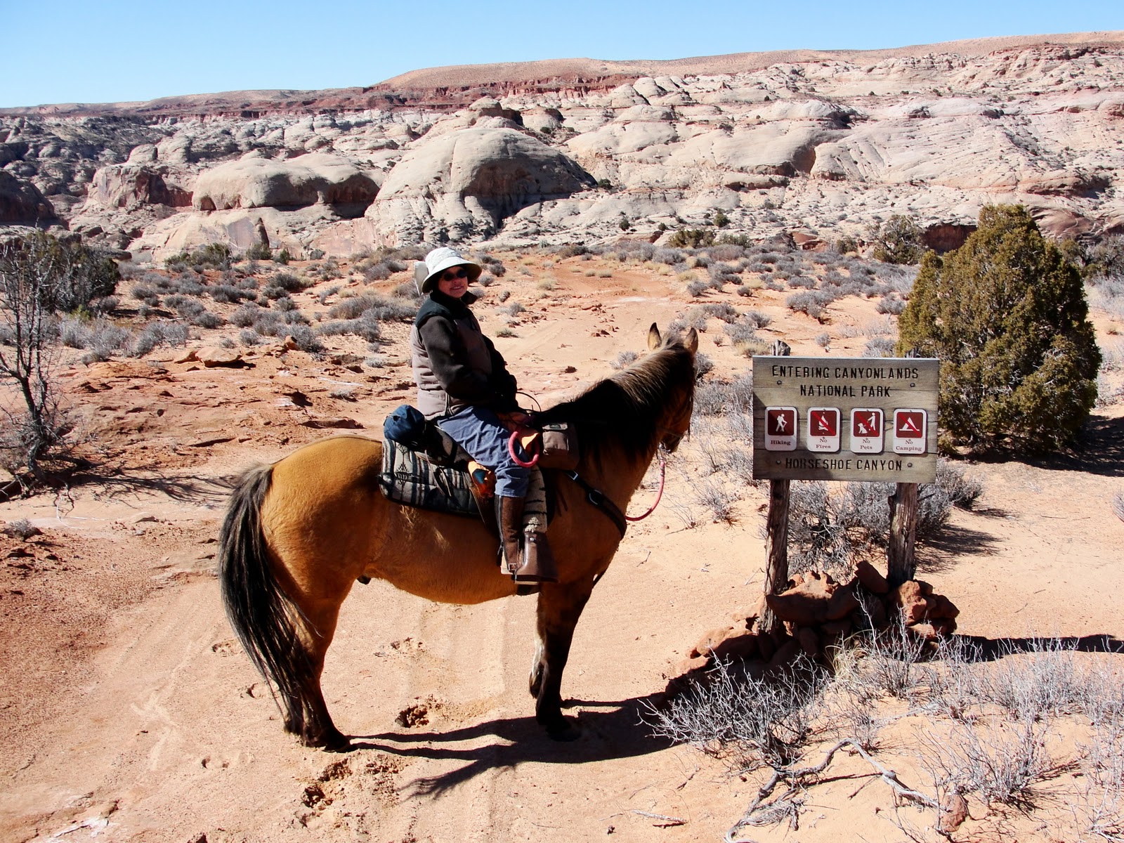
Once the horses had recovered from their morning 5K Freedom Run, we drove a short distance to the Canyonlands National Park Horseshoe Canyon trailhead to begin our ride.
The photo is taken from near the trailhead, showing Horseshoe Canyon below, Sugarloaf Butte in the near distance, and the LaSal Mountains, about 50 miles away.
Since we were crossing through the national park, Daisy had to stay in the trailer.  Poor girl.  However, since she had already had a nice run with the horses, she might have been secretly glad to have a rest.
Steve had called ahead for a permit and obtained the combination to get the horses through the Horseshoe Canyon gate. 
In spite of polishing up our junior high locker skills, we had a tough time with that lock.  It badly needed some WD40, and for awhile we didn't think we'd get through at all.  At last Steve managed to muscle it open and we got through.  Note Coco's sandy color in the above photo.  A few rolls in the dust has made him blend into the landscape.
Also in the photo above, you can see the smooth domes of Navajo sandstone at the top of the canyon, and the horizontal layers of Kayenta sandstone near the bottom.
The trail going down into Horseshoe follows an old road paid for by an oil company in 1929.  They hired about 20 local ranchers armed with sticks of dynamite, at the wage of about $4 per day.  It doesn't look much like a road now, but somehow 20's era trucks were able to negotiate the sandstone ledges and sandy dips. 
Note this juniper tree growing beside the old road bed:
The snake-like roots extend at least 10 feet as they seek to suck a little water out of the cracks in the sandstone.
Here is one of several three-toed allosaurus (a carnivorous dinosaur) tracks (each track is 10-12 inches in length) found along the way.
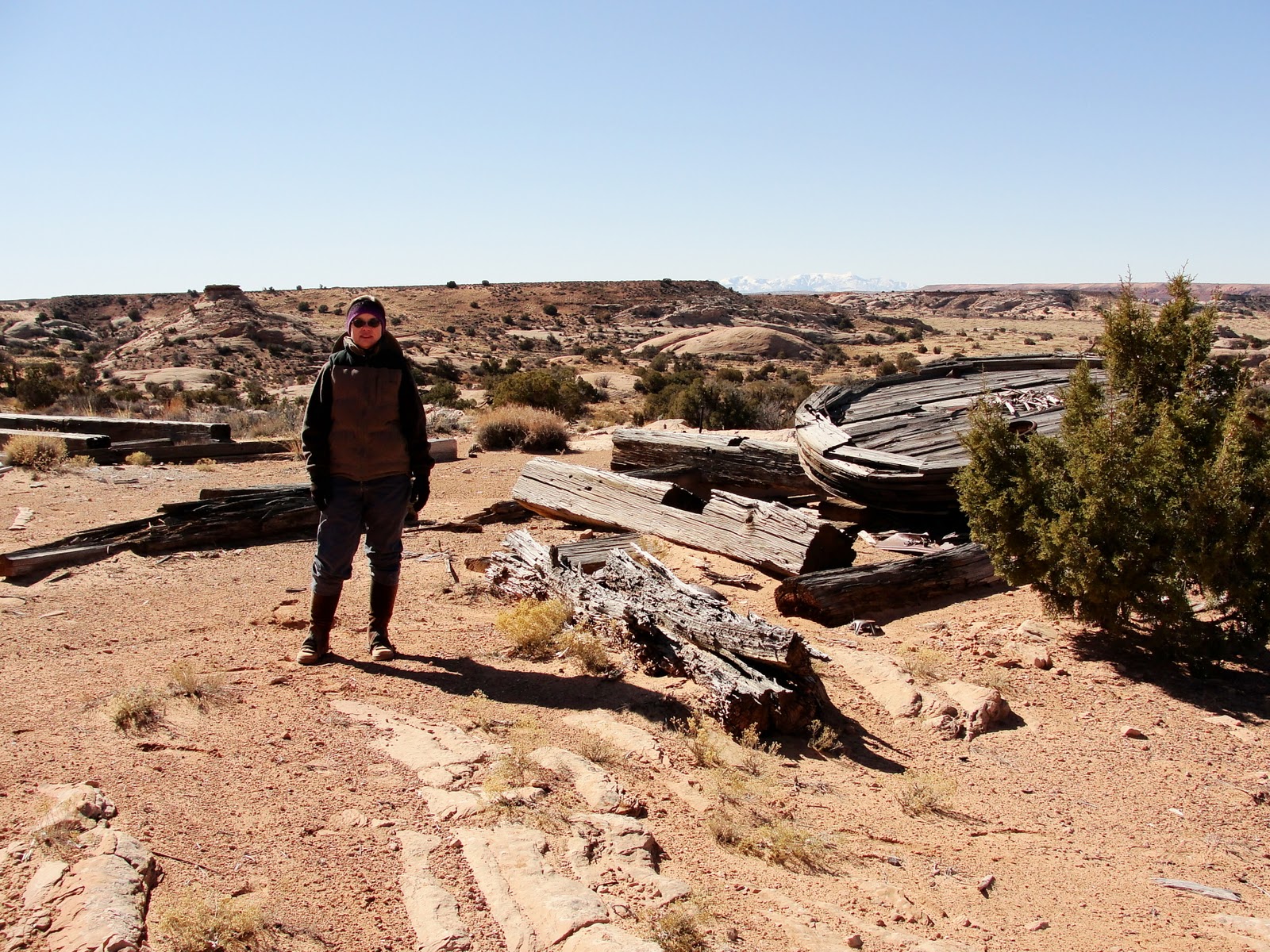
This old tank and some pipes that must lead to a spring is left over from early ranching days:
Horseshoe Canyon features a huge panel of Barrier Canyon style petroglyphs known as the Great Gallery.  Many of the figures are life-sized, and are some of the oldest, best preserved and most archeologically significant rock art on the Colorado Plateau.
 We visited the petroglyphs a few years ago, and I hope to go back someday, but this time, we wanted to explore the territory on the other side of the canyon.  So, up the other side we went, still following the old road.  On this eastern part, the "road" condition is even worse.  We led the horses to be safe, but they didn't have any trouble negotiating the Navajo sandstone, also known as "slickrock". 
Once we climbed out of the canyon, we left Canyonlands and rode on BLM land.  Note the sandy road on the mesa, perfect for barefoot riding.

February 25, 2011

Canyonlands Maze, Day 2, Morning

The next morning, we awakened to ice on the ceiling of the trailer, and an outside temperature of about 17 F.  Chilly!  Inside the trailer, the temp was 27 F, a bit toastier.  Our little catalytic heater warmed us to to above freezing, a welcome improvement.
Here's our gooseneck bed before the trip, just to show our luxurious accommodations:
The horses were tied to outside trailer rings overnight. 
At sunrise, Steve let them loose to dine on a bale of weed free hay (required on all government-owned land to prevent the spread of noxious weeds) we had brought along, plus some equally weed-free alfalfa cubes.  Steve took off their lead ropes, thinking they would hang close with maybe a short jaunt to the cow carcass-adorned spring for water. 
Wrong.  They must have taken the lack of lead ropes and hobbles for a license to explore their new "pasture."  They took off, with dear faithless Daisy joyfully racing along with her horse friends.  We followed much more slowly, across a landscape that stretched forever, roughly 20 square miles of open territory between one lonely fenceline and the rim of Horseshoe Canyon.
I didn't have the presence of mind or camera to photograph them galloping with their tails flagged and heads up, enjoying their unexpected freedom, but it was a pretty, if concerning, sight. Those fools ran for a full 2 miles, completely out of view.  We walked a quarter mile to a gate we had driven through on the way in, thinking the horses would stop at the fence.  Not.  We climbed a little hill and looked around.  No horses in sight.  After scouting around for hoofprints to see which direction they went, we finally saw them as a white and a brown speck in the distance.  We watched for a few moments and decided they were coming our way.  They trotted back, coming right up to us.  As a reward for returning on their own, they got a couple of handfuls of sweet feed.  We breathed a big heave of relief that we didn't have to spend the day hunting them. 
So, after a 4 mile romp for them and an adrenaline-charged start to the day for all of us, the boys finished their breakfast, albeit with Boss securely shackled.  Daisy had returned with them and enjoyed lounging around camp while digesting dog food and bits of well-aged cow rib.
By 10 AM, we were ready to ride.

February 24, 2011

Canyonlands Maze, Day 1

Both humans and animal friends at our house were growing weary of snow.  Steve noted that the top of the trailer was mostly snow-free, and he took that as a sign that it was time to go riding somewhere.  So, we loaded up and headed for southern Utah.  We drove about 4.5 hours to BLM (Bureau of Land Management) rangeland just outside of the Maze district of Canyonlands National Park.

Hoodoos and unusual rock formations made for an interesting drive once we left the paved road.
This sign marks a remote 4 way intersection of dirt roads.
As we approached, the Maze, deep sandstone canyons cut through the high desert plateau.  This place is a geologist's dream, demonstrating the effect of wind and water erosion on sandstone over millions of years.
Though we loved the scenery, we also loved having snow-free, sandy paths to ride for many miles.  We saw a few cows, rabbits, and antelope, but no cars or people.
The above photo shows the snowy Lasal Mountains (near Moab), across the expanse of the Maze District and the Green River corridor.
On the afternoon we arrived, we rode for 7 beautiful miles along the rim of Horseshoe Canyon.
The high temp was about 40 F, a little chilly for us, but good for the horses who are still wearing their winter coats.
That night, we camped near a small pond, one of the few water sources in the area.  A flock of ducks hung out there.  When we brought to the horses to the pond for a drink, the ducks flew away, circling until we were finished and the coast was clear.  Then they'd return.  They weren't about to give up the only floatable surface for miles around.
Unfortunately, our camp site had a dead cow carcass nearby, which was still somewhat odiferous.  Fortunately, Daisy was able to salvage a delicious rib bone for her supper. 
We chowed down on canned stew, which tastes like ambrosia when you're hungry enough, then huddled in our gooseneck trailer's sleeping quarters, awaiting sunrise and another day on the trail.

February 19, 2011

Newborn

Licking,
Nuzzling,
Directing,
Nurturing.
No matter the species, a mama's love is a sight to behold.
A few days ago, we went for a walk down to the neighbor's barn about noon to see if there were any new babies. We saw one cow who appeared to be near birthing.  She was standing up, glancing anxiously at her sides, with some fluid coming out of her vaginal area.
An hour later, we went back, thinking the mama would still be in labor, and the baby was already nursing! We didn't see the birth, but we sure were close. Apparently the cow hadn't delivered the placenta yet, but she was already doing a fine job of mothering.

February 12, 2011

Still Snowy

On this date in 2009 (and most years), the snow was almost gone in the pasture:This year, we still have 6 inches of compacted snow:
No riding yet.  Looks like we'll have to trek down to southern Utah to jump start the spring season.

February 8, 2011

On the Bunny Trail

Is there such a thing as too many bunny tracks?
Daisy doesn't think so. 
But sometimes multiple trails do present a dilemma: which trail should she follow first?

February 3, 2011

Snow Dragon and Snow Birds

Our porch thermometer read -25 F this morning. 
I took this photo a couple of years ago, but it tells the story of our early morning weather better than anything else I have to offer.
Boss seems very tolerant of the starlings this morning.  These birds hang around to pick seeds out of the hay, then fly up to perch on Boss's back, where his dark color soaks up a little warmth from the sun. 
The birds look content up there.
As of mid-morning, we have no wind, clear skies, and we've warmed up to 0 degrees.  No new snow here, but the mountains north of us got some.  
Hope everyone is staying warm out there in blogland.

February 1, 2011

Best Insulation

With wind chill, the morning's temperature is well below zero, but Boss stays warm and cozy in his dun brown horsehair coat, just furry enough, with a black line down the back, black accent around the eyes, black stockings and subtle zebra stripes on the legs.  A quirky lopsided star on his forehead completes the ensemble.  This handsome coat is designed by C.*, and amazingly suited to all conditions. 
As you can see, the coat provides so much insulation that Boss's body heat does not melt the snow on his back.  The coat is cleverly devised so that Boss himself can adapt his coat's thickness to seasonal conditions, simply by growing more horsehair, or shedding the extra.  Who could imagine a more ingenious and convenient strategy?     
* C. = Creator.  C. also goes by numerous other names, depending on one's beliefs, culture or linguistic preference.

LinkWithin

Blog Widget by LinkWithin